Signal Peak Run

Scouty

Member
Signal peak looks like a good run for both stock and built rigs. The trail up to the peak is pretty mild, however eagle lake and fordyce are nearby if those with modified trucks want something more challenging. There are also rivers and lakes in the area where we can have lunch. How many people are interested and can go on June 1st?

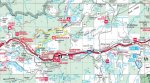
Directions: there are two different ways to get to the top of signal peak. The easy way, and the hard way. For the easy way, take the cisco grove exit from highway 80 and go north over the freeway. Turn left on the frontage road and make the first right just before the campground. This trail leads to fordyce reservoir. At about 7 miles from the pavement, look for a trail on the left. This trail leads up to the top where the radio towers and old signal house are. (from ttora site)

could meet in Auburn for coffee, there are a few grocery stores there as well to grab something for lunch.

signal_peak_01.jpg

signal_peak_02.jpg

signal_peak_03.jpg
 
Last edited:
Sounds like a great trip. I'm in.

We need to get some more details on the trail on the left, as it could be easy to miss if un marked.

I know I've see the sign to signal peak from the indian springs staging area, just north of the bathrooms. I suspect this is a tougher route, vs from the road that leads to fordyce lake.
 
I think la lou bontes is at the forest hill exit, which is an easy on and off exit.

Google maps says 47 minutes from my house, so that's an hour+ in Scout time for sure.
 
46 miles from Auburn to cisco grove exit. Probably will take a little less than an hour from Auburn. My Scout won't go much over 55mph. Meet in Auburn between 8:45 and 9:15, if we leave by 9:30 it should put us at the trail head by 10:30. So far it's Craig, rob and me.
 
Went up that way last year while exploring. The road is a little more beat up than last year but still manageable for stock vehicles. Good view for sure. Gonna make it since the weekend thinned out. Will probably just meet you guys up there around 10:30. I'll just park at the entrance to the road.
 
Looks like I will be running alone as my wife and daughter won't make be able to make it.

So I have an open seat or 2 if somebody wants to meet up somewhere.

I have 5 seat belts.

Matt is the plan to eat lunch up there? If it turns out to be too windy we can always head to the lake.
 
Matt is the plan to eat lunch up there? If it turns out to be too windy we can always head to the lake.

I'm not sure how long it takes to go up to the tower and back, but was thinking we would find some water to have lunch by.
 
Sounds good rob.

Here's a map I down loaded from the nat. Forest. Web site.

I highlighted with yellow the gravel road which leads to an ohv trail I believe this is the easiest route.

The brown line is the other ohv route which might be harder.

To make it even more fun there is a trail from the campground over to the trail head so we can avoid the freeway to get to indian springs staging area. So once we get off at the cisco grove exit, some can take the gravel road to the top and others take the campground trail over to the staging area which is where the trail head is on the west side of the mountain.
 

Attachments

  • Signal peak.jpg
    Signal peak.jpg
    101.1 KB · Views: 351
Last edited:
Ok, michael, myself and possibly bill will be meeting you guys up at the staging area. It's about an additional hour drive for me to go into Auburn then up 80. See you fools there!
 
Had a great time, 8 trucks total showed up. Even distribution of 800's and II's. To our suprise John Glancy made the trip with us, he wheeled an 800 he acquired from Jeff. The group got seperated at one point so not everyone made it up to the peak, but was fun for those of us who didn't make it to the top hanging out by the mosquito lake. Some headed back early, Craig, rob and his group and I ventured toward the fordyce trail. Here are some pictures...viva monte negro!

ry%3d480

ry%3d480

ry%3d480

ry%3d480

ry%3d480
 
Back
Top